I want 2011 Census data for a range of area types...
Main Content
Find Statistics for an Area
This route is designed to enable you to have access to a large amount of data for a range of area types, easily and quickly.
Simply enter the area name or a valid postcode:


- Then click the 'search' button

Choose from the resulting list by clicking on the topic

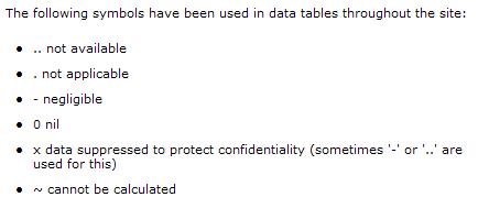
Symbols used in place of data
Sometimes it is not always possible to provide data for all areas, were this is not possible, the actual data value may be substituted by a symbol.

Due to changes to some Output Areas (OAs) as a result of data from the 2011 Census, areas which have changed may display a .. or a ~ symbol instead of data. This is because an actual data value cannot be calculated for that area. It may be possible that data is available in another part of the site, such as the 'Custom Route' or the 'Topics Route'
Tips for using the Find Statistics for an area route:
When I enter the ward name St. Helen's the search results in an error - The area search within this part of the site is quite basic, it will not recognise non-standard characters such as apostrophes or full stops. For example if you selected an area such as St. Helens it would return an error message:

You need to keep the search as simple as possible, for example using the word Helens would return a list of possible areas

Go to the Find Statistics for a Area route from the Neighbourhood Statistics homepage
Go to the 2011 Census homepage

